


Inagi Yanokuchi Station Area
Project Entity
Inagi City
Overview of the District
Located in the northeastern part of Inagi City, this area is the closest to the city center within the city limits and serves as the eastern gateway adjacent to Kawasaki City in Kanagawa Prefecture. Within the area, four urban planning roads are planned around Yanokuchi Station on the JR Nambu Line (Route 3-1-6 Minami-Tama Oken Main Line, Route 3-4-11 Yanokuchi Omaru Line, Route 3-4-29 Yanokuchi Station South Exit Line, Route 3-4-30 Yanokuchi Station North-South Line), aiming for a multifunctional and complex land use structure ranging from advanced industries to residential areas.
Business Activities
Urban Planning Decision
September 9, 1991, Inagi City Public Notice No. 63
Announcement of Business Plan Decision
January 27, 1993, Inagi City Public Notice No. 1
Project Implementation Period
From fiscal year 1992 to fiscal year 2026
Area of Implementation
16.8 hectares
Reduction Rate
23.08% (average)
Project Cost
Total Project Cost
27.8 billion yen
National Treasury Subsidy
4.4 billion yen
National Treasury Subsidy
2.6 billion yen Super levee project related
Tokyo Metropolitan Subsidy
4.6 billion yen (including 2.4 billion yen from the Tokyo Metropolitan Government: When the Tokyo Metropolitan Government entrusts the Land Readjustment Project carried out by municipalities to the Tokyo Metropolitan Urban Development Public Corporation, the equivalent amount of subsidies to municipalities is provided as "Tokyo Metropolitan Government Grants" and is directly granted to the public corporation)
Tokyo Metropolitan Government Contribution
4 billion yen for land and compensation costs for urban planning road (Tama 3.1.6 Minami-Tama Ridge Main Line)
Other Burdens and Fees
100 million yen
General City Revenue
12.1 billion yen
Project Progress Status
Since the fiscal year 1999, we have started relocating buildings from the Tsurukawa Road and the super levee project area. Currently, we are working on the development of the area north of Yanokuchi Station and making progress on the project.
|
Overall Plan |
Until the end of fiscal year 2022 |
Progress Rate |
|
|---|---|---|---|
|
Urban Planning Road |
1,393 meters |
1,014 meters |
72.8% |
|
Block Road |
4,265 meters |
2,285 meters |
53.6% |
|
Designated Area for Temporary Land Exchange |
103,813 square meters |
54,255 square meters |
52.3% |
|
Number of Building Relocations |
397 buildings |
Building 202 |
50.9% |
Related Projects
- JR Nambu Line Elevated Crossing Project Completed in Fiscal Year 2005 (Phase 1 Construction Area Centered on Yanokuchi Station)
- Super levee project completed in fiscal year 2006 (AB section)
- Tamagawahara Bridge Replacement Project Completed in April 2006
- Minami-Tama Station Ridge Main Line Area Development Project - April 2006 Traffic Opening
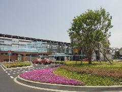
Surroundings of Inagi Yanokuchi Station

Design plan for the area around Inagi Yanokuchi Station
To view the PDF file, you need "Adobe(R) Reader(R)". If you do not have it, please download it for free from Adobe Systems' website (new window).
Please let us know your feedback on how to make our website better.
Inquiries about this page
Inagi City Urban Environment Management Department Land Readjustment Division
〒206-8601 Tokyo, Inagi City, Higashi-Naganuma 2111
Phone number: 042-378-2111 Fax number: 042-378-9719
Contact Inagi City Urban Environment Management Department Land Readjustment Division