


Viewing city planning maps such as land use zones, etc.
Update date: April 1, 2024
Terms of Use <br id="3"/>This urban planning map is current as of March 31, 2024.
The "Land Development and Specific Filling Regulation Act" (commonly known as the Filling Regulation Act), which will come into force on July 31, 2024, designates the entire city of Inagi as a "land development and other construction restricted area." This is scheduled to be reflected in the city planning map from fiscal year 2025.
Inagi City does not guarantee the complete accuracy of this map information or that it will work properly on all users' computers. In addition, we will not be held responsible for any damages that may occur as a result. The copyright for information on topographical maps, urban planning maps, etc. belongs to Tokyo Metropolitan Government and Inagi City. Please view the following only if you agree to the above.
![]() Inagi City Urban Planning Map (PDF: 3,831KB)
Inagi City Urban Planning Map (PDF: 3,831KB)
![]() Inagi City Urban Planning Map (Summary) (PDF: 3,529KB)
Inagi City Urban Planning Map (Summary) (PDF: 3,529KB)
If you would like to print an enlarged drawing, please print it out using a print screen, etc.
Regarding the productive green area, please see the Inagi City Urban Planning Facility Map and the Inagi City Production Green Area Map .
If you have any questions, please contact the Inagi City Urban Construction Department, Town Planning Division.
Please tell us over the phone the name or address of the place you want to look up, and if it is in a rezoning area, the temporary land number.
Internet provision services such as city planning information provided by the Tokyo Metropolitan Bureau of Urban Development
![]() (Tokyo Metropolitan Government) Internet provision service for urban planning information, etc.
(Tokyo Metropolitan Government) Internet provision service for urban planning information, etc.
[Note] Please be sure to download the district planning plan from the Inagi City website "Location of district planning and list of planning documents" . In addition, the following "Recent changes in urban planning such as site area" are not reflected in the Internet services provided by Tokyo Metropolitan Government, such as urban planning information.
Recent changes in urban planning, such as zoning
Changes to the eastern part of Nanzan (notified on November 28, 2020)
![]() Nanzan eastern district plan map (PDF: 691KB)
Nanzan eastern district plan map (PDF: 691KB)
![]() Nanzan Eastern District Before and After Change (PDF: 3,133KB)
Nanzan Eastern District Before and After Change (PDF: 3,133KB)
Inquiries to related organizations in Inagi City
![]() List of relevant organizations in Inagi City (reference) (PDF: 1,345KB)
List of relevant organizations in Inagi City (reference) (PDF: 1,345KB)
Please contact the Tokyo Tama Architectural Guidance Office for consultation regarding building certification applications and architectural guidance regarding the Building Standards Act. For other inquiries, please see the list of related organizations in Inagi City (reference) above.
About high altitude districts
Please check the legend on the Inagi City urban planning map to see the type of elevation district.
The height restrictions for each type are as shown in the diagram below. For more detailed restrictions, please see the Inagi City Urban Planning Map (Summary).
- Some districts have a maximum height limit for buildings, etc. in their district plans. For details, please check the location of the district plan and the list of planning books .
- In the case of construction projects for mid- to high-rise buildings, those with a height exceeding 10 metres are subject to the Inagi City Housing Development Guidelines, etc. For the maximum height limit, please refer to the Guidelines Regarding the Maximum Height of Mid- to High-rise Buildings Constructed in Inagi City .
- Please contact the Tokyo Tama Architectural Guidance Office regarding the north side, road, adjacent land diagonal line restrictions, etc. according to the Building Standards Act.
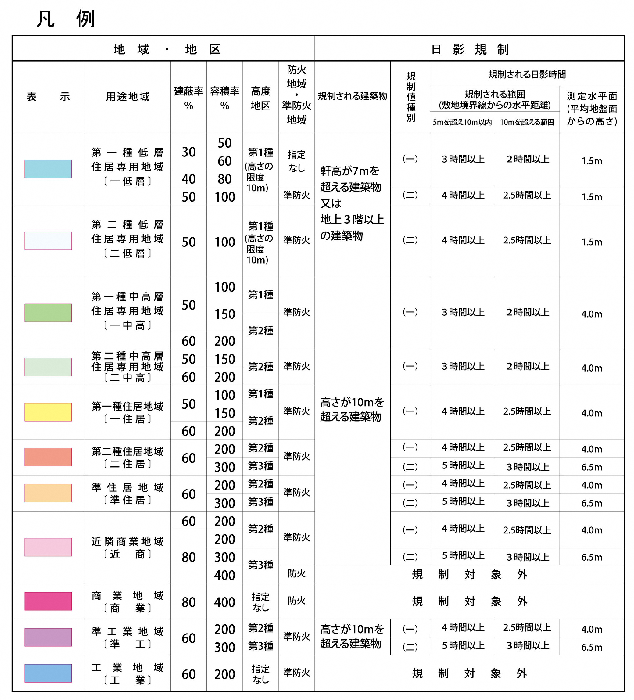
City planning map legend
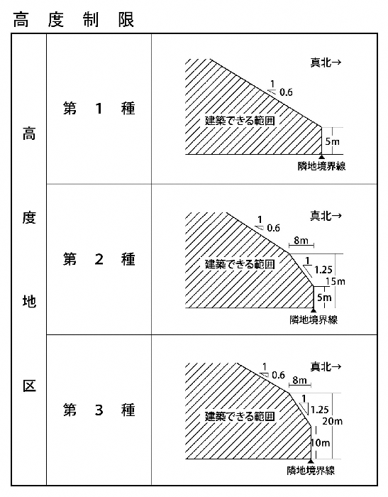
Map of altitude districts
Adobe Acrobat Reader DC (formerly Adobe Reader) is required to open PDF files.
If you don't have it, you can download it for free from Adobe.
![]() Download Adobe Acrobat Reader DC
Download Adobe Acrobat Reader DC
Inquiries regarding this page
Inagi City Urban Construction Department Town Development Planning Division
2111 Higashi-Naganuma, Inagi-shi, Tokyo
Phone: 042-378-2111 Fax: 042-378-9719