


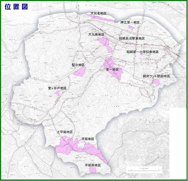
Completed Project Areas
Keio Yomiuri Land Station Front Area
The area in front of Keio Yomiuri Land Station is located in the eastern part of the city, south of Keio Yomiuri Land Station, which is adjacent to the Keio Line on the north side and the Yomiuri Land Line on the west side.
-
Project Name
- Keio Yomiuri Land Station Front Land Readjustment Project
- Implementation Method
- Union Implementation
- Area of Implementation
- 3.0 hectares
-
Approval Date
- October 1, 1975
- Project Duration
- 5 years
- Number of Union Members
- 9 people
- Total Project Cost
- 418,880,000 yen
-
Land Exchange Disposal Date
- March 31, 1980
- Average Combined Reduction Rate
- 34.03%
Inagi Hirao District
The Hirao area of Inagi is located in the southern part of the city, bordered to the north by a golf course and the prefectural boundary with Kawasaki City, and to the south by Hirao Chuo Street.
-
Project Name
- Inagi Hirao Land Readjustment Project
-
Implementation Method
- Union Implementation
- Area of Implementation
- 22.5 hectares
- Approval Date
- December 1, 1975
- Project Duration
- 6 years
- Number of Union Members
- 137 people
- Total Project Cost
- 2,813,181,000 yen
- Land Exchange Disposal Date
- November 28, 1981
- Average Combined Reduction Rate
- 31.52%
Inagi First District
The Inagi First District is located in the central part of the city, incorporating the area north and south of Inagi Station, with Koyodai Park Avenue running vertically through the district.
- Project Name
- Inagi First Land Readjustment Project
- Implementation Method
- Union Implementation
-
Area of Implementation
- 21.0 hectares
- Approval Date
- December 1, 1975
- Project Duration
- 16 years
- Number of Union Members
- 99 people
- Total Project Cost
- 5,806,346,000 yen
- Land Exchange Disposal Date
- December 1, 1990
- Average Combined Reduction Rate
- 34.15%
Inagi Omaru North District
The Omaru North District of Inagi City is located at the northern edge of the city, bordered by the Tama River to the north, the Omaru Yato River to the south, businesses to the west, and the North Green Space Park to the east.
- Project Name
- Inagi Omaru North Land Readjustment Project
- Implementation Method
- Union Implementation
- Area of Implementation
- 5.2 hectares
- Approval Date
- December 12, 1991
- Project Duration
- 4 years
- Number of Union Members
- 28 people
- Total Project Cost
- 1,027,534,000 yen
- Land Exchange Disposal Date
- October 23, 1995
- Average Combined Reduction Rate
- 36.50%
Inagi Dogayato District
The Inagishi Dogayato District is located in the southwestern part of the city, bordered on the east by Nagamine Elementary School and on the south by Tsurukawa Road.
- Project Name
- Inagi Dogayato Land Readjustment Project
- Implementation Method
- Public Corporation Implementation
- Area of Implementation
- 1.2 hectares
- Approval Date
- January 4, 1993
- Project Duration
- 5 years
- Total Project Cost
- 1,097,000,000 yen
- Land Exchange Disposal Date
- July 15, 1997
- Average Combined Reduction Rate
- 32.00%
Inagi Tatekida District
The Inagi Tatekidai area is located in the central part of the city, bordered by the Oine Main Road to the north and Chuo Park to the south.
- Project Cost
- Inagi Tatekidai Land Readjustment Project
- Implementation Method
- Union Implementation (Adoption of the Participating Member System by the Housing and Urban Development Corporation)
- Area of Implementation
- 7.1 hectares
- Approval Date
- August 3, 1992
- Project Duration
- 7 years
- Number of Union Members
- 73 people
- Total Project Cost
- 4,122,000,000 yen
- Land Exchange Disposal Date
- September 30, 1998
- Average Combined Reduction Rate
- 32.02%
Inagi Hirao Minami District
The Hirao Minami area of Inagi City is located at the southern end of the city, bordered to the north by a city road, to the west by the Hirao Nyushoduka green space designated in the District Plan, to the south by the prefectural boundary with Kawasaki City, and to the east by a city road and existing residential areas.
- Project Name
- Inagi Hirao South Land Readjustment Project
- Implementation Method
- Union Implementation
- Area of Implementation
- 3.4 hectares
- Approval Date
- March 27, 1998
- Project Duration
- 5 years
- Number of Union Members
- 19 people
- Total Project Cost
- 1,816,802,000 yen
- Land Exchange Disposal Date
- March 20, 2003
- Average Combined Reduction Rate
- 54.99%
Inagi Omaru South District
The Omaru Minami area of Inagi is located in the northern part of the city, bordered to the north by the main regional road Kawasaki-Fuchu Line, to the south by Yamazaki Street and Inagi City Dai 1 Junior High School, and to the east by Inagi City Dai 3 Elementary School.
- Project Name
- Inagi Omaru South Land Readjustment Project
- Implementation Method
- Union Implementation
- Area of Implementation
- 10.1 hectares
- Approval Date
- May 29, 1995
- Project Duration
- 11 years
- Number of Union Members
- 178 people
- Total Project Cost
- 2,767,839,000 yen
- Land Exchange Disposal Date
- March 3, 2006
- Average Combined Reduction Rate
- 26.55%
Inagi Oshidate First District
Inagi Oshitate First District is located in the northeastern part of the city, approximately 0.7 kilometers north of Inagi-Naganuma Station on the JR Nambu Line.
-
Project Name
- Inagi Oshitate First Land Readjustment Project
-
Implementation Method
- Union Implementation
-
Area of Implementation
- 1.3 hectares
-
Approval Date
- December 3, 2013
-
Project Duration
- 2 years
-
Number of Union Members
- 7 people
-
Total Project Cost
- 312,767,000 yen
-
Land Exchange Disposal Date
- July 10, 2015
-
Average Combined Reduction Rate
- 35.07%
East Area of Inagi-Naganuma Station
The Higashi-Naganuma area of Inagi-Naganuma Station is located in the northern part of the city, adjacent to the JR Nambu Line Inagi-Naganuma Station on the west side, close to Inagi Ohashi Street on the east side, and bordering the side road of the elevated JR Nambu Line on the south side.
- Project Name
- Inagi-Naganuma Station East Land Readjustment Project
- Implementation Method
- Individual Implementation (Joint Implementation)
- Area of Implementation
- 0.5 hectares
- Approval Date
- July 28, 2020
- Project Duration
- 1 year
- Number of Landowners
- 5 people
- Total Project Cost
- 170,545,000 yen
- Land Exchange Disposal Date
- June 17, 2021
- Average Combined Reduction Rate
- 31.94%
Inagi Kamihirao District
The Inagi Kamihirao area is located about 0.8 kilometers north of Kurihira Station on the Odakyu Electric Railway Tama Line, bordered to the south by the Hirao Housing of the Tokyo Metropolitan Housing Supply Corporation, to the east by the Inagi Hirao Land Readjustment Project area, and to the west by the Kuriki First Land Readjustment Project in Kawasaki City.
- Project Name
- Tama Urban Planning Project Inagi Kamihirao Land Readjustment Project
- Implementation Method
- Union Implementation
- Area of Implementation
- 25.1 hectares
- Approval Date
- July 29, 2010
- Project Duration
- 12 years
- Number of Landowners
- 97 people
- Total Project Cost
- 8,912,700,000 yen
- Land Exchange Disposal Date
- March 1, 2019, October 12, 2021
- Average Combined Reduction in Steps
- 48.84%
Minami District of Inagi City First Elementary School
The Inagi City First Elementary School South District is located in the northeastern part of the city, approximately 0.9 kilometers southwest of Yanokuchi Station on the JR Nambu Line, approximately 0.9 kilometers southeast of Inagi-Naganuma Station on the JR Nambu Line, and approximately 1.1 kilometers northeast of Inagi Station on the Keio Sagamihara Line.
- Project Name
- Land Readjustment Project for Inagi City First Elementary School South
- Implementer
- Individual Implementation (Consent Implementation)
- Area of Implementation
- 0.2 hectares
- Approval Date
- October 7, 2022
- Project Duration
- 1 year
- Number of Landowners
- 3 people
- Total Project Cost
- 25,162,000 yen
- Land Exchange Disposal Date
- October 18, 2023
- Average Combined Reduction Rate
- 14.88%
Please let us know your feedback on how to make our website better.
Inquiries about this page
Inagi City Urban Environment Management Department Land Readjustment Division
〒206-8601 Tokyo, Inagi City, Higashi-Naganuma 2111
Phone number: 042-378-2111 Fax number: 042-378-9719
Contact Inagi City Urban Environment Management Department Land Readjustment Division