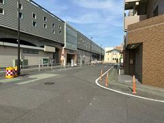
Inagi Minamitama Station area
Updated: April 22, 2024
Business entity
Inagi City
District overview
It is located in the northwest of Inagi City, at the eastern entrance to Tama New Town. Two urban planning roads (Ta-3-3-7 Inagi-Fuchu Line, and Ta-3-4-11 Yanoguchi Daimaru Line) are planned and located around JR Nambu Line Minami-Tama Station, and the area aims to achieve a harmonious mixed land use for residential, commercial, and industrial purposes.
Business Contents
City planning decision
September 9, 1991 Inagi City Notice No. 65
Announcement of business plan decision
January 27, 1993 Inagi City Announcement No. 3
Project implementation period
From fiscal year 1992 to fiscal year 1998
Implementation area
12.2 hectares
Step loss rate
25.21% (average)
expense
Total project cost
16.4 billion yen
national treasury subsidy
3 billion yen Maintenance costs for urban planning roads (multi-line 3, 4, 11 Yanoguchi Daimaru Line, etc.)
Tokyo subsidy
1.6 billion yen Maintenance costs for urban planning roads (Nos. 3, 4, and 11 Yanoguchi Daimaru Line)
Tokyo Metropolitan Government contribution
3.5 billion yen Land and compensation costs for urban planning roads (Taiwan Routes 3, 3, and 7 Inagi Fuchu Line)
Other contributions, etc.
100 million yen
City general revenue
8.2 billion yen
business progress situation
The relocation of buildings began in the area south of the station in fiscal 1999. Currently, development of the northwestern part of the area has begun and work is progressing smoothly.
| Overall plan | Until the end of fiscal year 2022 | Progress rate | |
|---|---|---|---|
| urban planning road | 522 meters | 162 meters | 31.0% |
| section road | 2,384 meters | 1,401 meters | 58.8% |
| Designated area for temporary replacement land | 75,911 square metres | 69,783 square metres | 91.9% |
| Number of buildings relocated | 239 buildings | 184 buildings | 77.0% |
Related Business
- JR Nambu Line continuous grade separation project completed in 2015 (2nd phase construction section)
- Koremasa Bridge Reconstruction and Widening Project Completed in 2014
The area around Inagi Minamitama Station
View of the project area from Koyodai district
Maintenance status on the north side of the station
Yatterman Statue

Minamitama Station South Side Off-grid Project
Blueprint of the area around Inagi Minamitama Station
Adobe Acrobat Reader DC (formerly Adobe Reader) is required to open PDF files.
If you don't have it, you can download it for free from Adobe.
![]() Download Adobe Acrobat Reader DC
Download Adobe Acrobat Reader DC
Inquiries regarding this page
Inagi City Urban Environment Development Department Land Readjustment Division
2111 Higashi-Naganuma, Inagi-shi, Tokyo
Phone: 042-378-2111 Fax: 042-378-9719


