


What is address arrangement business?
Update date: April 1, 2021
What is address arrangement?
The current address and location of Inagi City are displayed using the lot number, which is the number of the land.
Land numbers were not originally established to identify people's residences, but were numbers given to land during the Meiji period primarily for the purpose of tax collection.
As a result, whenever land is divided or roads are constructed, the regularity of the numbers is lost, and the situation becomes very difficult to understand, such as numbers jumping around or many houses being built on the same lot number. .
In order to resolve this situation, we are moving forward with organizing addresses and locations to make them easier to understand.
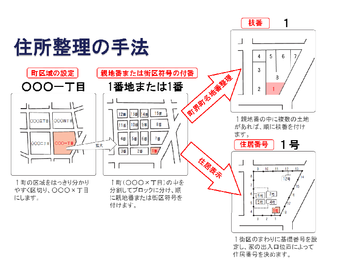
![]() Address arrangement business pamphlet (PDF: 898KB)
Address arrangement business pamphlet (PDF: 898KB)
Effects of address arrangement
Address organization can be expected to improve the convenience and safety of citizens' lives by organizing the display of addresses and locations in conjunction with reviewing town areas and setting blocks. In addition, it will be possible to understand the number of households in each town area, which can be expected to not only improve and improve local activities but also be effective in responding to disasters.
Method of organizing addresses
There are two methods of address sorting : ``chokai town name lot number sorting,'' which renumbers land, and ``dwelling indication,'' which assigns addresses based on the location of buildings.
Current situation of Inagi City
Inagi City was formed in 1896 by the merger of six villages: Yanoguchi Village, Higashi Naganuma Village, Daimaru Village, Hyakumura, Sakahama Village, and Hirao Village, and Inagi Village was born. After that, the Oshidate area was incorporated in 1952, and as the population increased, it became Inagi Town in 1950, and Inagi City in 1962. With the progress of the Tama New Town project, the Koyodai, Nagamine, and Wakabadai districts were born, and together with the previous seven districts, the area now consists of 10 districts.
Regarding the organization of addresses, in line with the opening of the Tama New Town area, town name and land number adjustments were implemented in the Koyodai area in 1988, the Nagamine area in 1994, and the Wakabadai area in 1998. Furthermore, in 1990 and 1993, part of the Hirao district in established urban areas underwent a town name rearrangement.
capital name |
Town name | Number of small characters | Area (hectares) |
remarks |
|---|---|---|---|---|
Yanoguchi |
17 characters | 256.6 |
||
Higashinaganuma |
17 characters | 193.4 |
||
Daimaru |
27 characters | 318.8 |
||
100 villages |
16 characters | 130.0 |
||
Sakahama |
39 characters | 372.5 |
||
| Hirao 1-chome | 38.7 |
July 1, 1990 Change of town name and lot number (1-3-chome newly established) |
||
Hirao 2-chome |
39.5 |
|||
Hirao 3-chome |
34.4 |
|||
Hirao 4-chome |
37.6 |
|||
Hirao subtotal |
150.2 |
|||
Oshidate |
6 characters | 82.9 |
||
Koyodai 1-chome |
6.7 |
July 1, 1988 New town area established |
||
Koyodai 2-chome |
7.9 |
|||
Koyodai 3-chome |
15.9 |
|||
Koyodai 4-chome |
30.9 |
|||
Koyodai 5th Street |
7.4 |
|||
Koyodai 6-chome |
25.2 |
|||
Koyodai subtotal |
94.0 |
|||
Nagamine 1-chome |
22.0 |
October 1, 1994 New town area established |
||
Nagamine 2-chome |
16.4 |
|||
Nagamine 3-chome |
28.4 |
|||
Nagamine subtotal |
66.8 |
|||
Wakabadai 1-chome |
49.1 |
October 1, 1998 New town area established |
||
Wakabadai 2-chome |
25.3 |
|||
Wakabadai 3-chome |
28.0 |
|||
Wakabadai 4-chome |
29.4 |
|||
Wakabadai subtotal |
131.8 |
|||
total |
1,797.0 |
|||
Adobe Acrobat Reader DC (formerly Adobe Reader) is required to open PDF files.
If you don't have it, you can download it for free from Adobe.
![]() Download Adobe Acrobat Reader DC
Download Adobe Acrobat Reader DC
Inquiries regarding this page
Inagi City Urban Construction Department Town Development and Revitalization Division
2111 Higashi-Naganuma, Inagi-shi, Tokyo
Phone: 042-378-2111 Fax: 042-378-9719