


Location of the city
Update date: October 22, 2021
Location of Inagi City
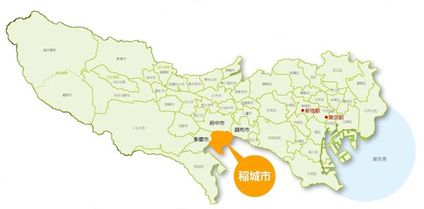
Our city is located at the eastern end of the Minamitama district, bordering Kawasaki City, Kanagawa Prefecture from the southeast to the west, Fuchu City and Chofu City to the north across the Tama River, and Tama City to the west.
It is located approximately 25 kilometers southwest of Shinjuku in central Tokyo (139° 30' 16" east longitude, 35° 38' 17" north latitude), approximately 5.3 kilometers east-west, north-south, and has an area of 17.97 square kilometers, which is the northern boundary. It is almost triangular in shape with the Tama River on one side.
On the south side, parallel to the Tama River, are the gentle Tama Hills (45 to 80 meters above sea level) (highest 162 meters above sea level), and the Misawa River flows through the center of the city, dividing the city into northwest and southeast. The Yato River flows from the southwest to the northeast in the Daimaru area.
Inquiries regarding this page
Inagi City Planning Department Secretary Public Relations Division
2111 Higashi-Naganuma, Inagi-shi, Tokyo
Phone: 042-378-2111 Fax: 042-377-4781