Last updated: June 27, 2017
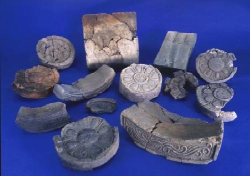
Roof tiles and bricks excavated from the Kawara Yato kiln site
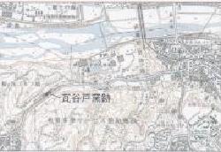
Location of Kawayato kiln site
The remains of the Kawarayato kiln are located along the Kawasaki Highway on the west side of the city hospital in Daimaru, Inagi City. This ruin was known as the remains of a kiln that fired tiles for Musashi Kokubunji Temple during the Nara period. The first excavation survey was conducted in 1955, sponsored by Inagi Village. During this survey, two kiln ruins were discovered, and it was found that these kilns produced tiles from the founding period of Musashi Kokubunji Temple and square tiles related to Musashi Kokufu. Ta.
In 1998, a second excavation survey was conducted in conjunction with the widening construction of Kawasaki Highway. In this survey, the area to the west of the survey area in 1955 was surveyed. A preliminary confirmation survey was conducted in 1997, and the main survey began on March 3, 1998. For the sake of convenience, we set points A, B, and C from the east and excavated them sequentially. As a result, we confirmed one kiln ruin and one haybara from point A, one kiln ruin from point B, and one haybara from point C. (Ashes and discarded tiles are piled up in front of the kiln's fire pit.) The excavated artifacts include round tiles (marugawara) (male tiles), flat tiles (hiragawara) (female tiles), and round eaves tiles (nokimarugawara) (stirrup tiles) ), eave flat tiles (nokigawara), noshi tiles, square tiles, rectangular tiles, Sueki Etc. The excavation survey was completed on August 17, 1998, leaving many results.
Kiln A, which was discovered at the eastern end of Point A, was mostly destroyed by a concrete retaining wall, with only a small portion of the fire pit and vestibule remaining. It was the state. Although we do not know its overall form, it is likely to be an underground climbing kiln. A ash field spread out on the southwest side of the kiln ruins.
Kiln B is an underground, stepped kiln built by hollowing out the Inagi sand layer at Point B. It was discovered in almost complete form, and the size of the kiln is approximately 6.5 meters in total length and approximately 1.8 meters in maximum width, and the height from the fire pit to the top of the flue. is approximately 5.5 meters long. The firing chamber of the kiln has seven steps for firing tiles, and some of the steps are reinforced with ``sen'' to make it easier to place the products. I did.
A line drawing of a horse was discovered on the right side wall of the combustion chamber inside Kiln B, and it attracted attention. On the side wall, in an area measuring approximately 1 meter x 0.6 meters, there were three horses carved with sticks. The two horses drawn at the bottom have their saddles, hooves, manes, etc. expressed with strong lines, and the one drawn at the top is expressed with simple lines, in contrast to the two horses at the bottom. It had been. It is thought that the line drawings of horses were used for kamado-related rituals. It is a custom that is still practiced today to pray to the god of fire when building and firing a kiln. This is the first discovery in Japan that a line drawing of a horse was drawn inside the kiln.
Gebun is a letter sent to the county by the head of the town, and is a square piece of pottery (brick-shaped pottery placed on the floor of a building, about 28 cm long and wide). centimeter, approximately 8 centimeters thick). The text is 13 characters, ``Kamata-go no Osatsutsushimi Tegeshimasu Musashino-kuni Ebara-gun,'' which translates to ``Kamata-go no Osatsutsushimi Tegeshimasu Musashino-kuni Bara-gun.'' A letter of report from the mayor of Kamata-go (around present-day Ota Ward) to the government office of Ebara County, which ruled over parts of Shinagawa and Ota Ward. Shinbun). This is a valuable document that shows that at the time, when Kokubunji was being built, a basic corvée system of one county, one village, and one household was in place. Also discovered at the same time was a ``shusho no sen,'' which appears to have been used to practice letters before writing ``gebun.''
Kawarayato Kamaato and Musashikokubunji/Musashikokufu are located close to each other, approximately 3.5 to 4 kilometers in a straight line across the Tama River. This investigation revealed that the tiles and tiles fired at the Kawarayato kiln site were used during the founding period of Musashi Kokubunji Temple and for the Musashi Kokufu government. In particular, it has become clear that the square ink is for Musashi Kokufu, and the rectangular ink is for Musashi Kokubunji.
References cited.
“Kawarayato kiln site excavation survey report”
“Inagi City Cultural Properties Research Bulletin No. 2, No. 3, No. 4”
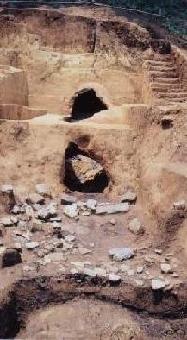
Full view of kiln B
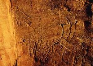
A line drawing of a horse drawn inside the kiln site
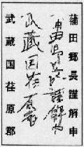
Decryption characters
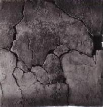
A square brick engraved with the interpretation
Inagi City Education Department Lifelong Learning Division Tel: 042-377-2121