Last updated: April 23, 2024
Inagi City
Located in the northern part of Inagi City, it is positioned as the northern core of Inagi City's central district. Centered on JR Nambu Line Inagi-Naganuma Station, urban planning roads Nos. 3, 4, and 14 Inagi-Naganuma Ekimae-dori Line are planned to run north-south, and the central zone in front of the station mainly consists of commercial, business, and service facilities, as well as residential areas. This is a district where land use is planned based on land.
September 9, 1991 Inagi City Notification No. 64
August 5, 1993 Inagi City Public Notice No. 30
From 1993 to 2020
10.6 hectares
24.70% (average)
17.6 billion yen
6.3 billion yen Maintenance costs for urban planning roads (multi-line Nos. 3, 4, 14 Inagi Naganuma Ekimae Street Line, etc.)
3.5 billion yen Maintenance costs for urban planning roads (Multiple Routes 3, 4, and 14 Inagi Naganuma Ekimae Street Line)
100 million yen
7.7 billion yen
The relocation of buildings began in the area north of the station in fiscal 2000. Currently, we are working on the development of the area around the station square on the south side of the station and the area north of the station, and are making progress with the project.
| Overall plan | Until the end of fiscal year 2022 | Progress rate | |
|---|---|---|---|
| urban planning road | 709 meters | 431 meters | 60.8% |
| section road | 3,081 meters | 1,374 meters | 44.6% |
| Designated area for temporary replacement land | 69,303 square meters | 34,379 square metres | 49.6% |
| Number of buildings relocated | 274 buildings | 141 buildings | 51.5% |
JR Nambu Line continuous grade separation project completed in 2015 (2nd phase construction section)
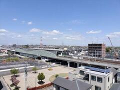
Maintenance status on the north side of the station

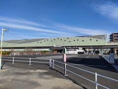
Elevated Inagi-Naganuma Station

Conditions of the south side of the station
Inagi City Urban Environment Development Department Land Readjustment Division Phone: 042-378-2111